Walking
Explore the coastline or the woodlands, the villages or the archaeological remains. Check our Visitor Map of the Black Isle for inspiration, and have a look at Getting Around to widen your horizons with public transport.
Find information on walks and trails in the Black Isle and nearby from the excellent site WalkHighlands.
There are two pocket-sized books with a number of local walks.

Loch Ness, Inverness, Black Isle and Affric: 40 Favourite Walks by Pauline and Helen Webster £6.99
Walks Easter Ross & The Black Isle Hallewell Pocket Walking Guide £2.95
There are a number of archaeology self-guided trails in the Highlands, which were promoted at a recent Highlands Archaeology Festival through the creation of a webpage. On the Black Isle listed are:
Hidden Black Isle Trail Trail to some of the hidden gems, mainly heritage, on the Black Isle.
A walk around Munlochy Walk leaflet to explore Munlochy, created by ARCH project.
Explore the ‘Chanonry’ – a walking tour around early Fortrose produced by the Kirkmichael Trust.
Guide to Kirkmichael in the Black Isle A guide to the church and graveyard
Active walker Julian Paren is adding walks around the Black Isle to the Geo-trips section of the Geograph website. If you follow the links below you will find for each walk a map with a GPS track and a series of images identified by their location with a description. There is also an introduction to the walk explaining its features, its length and the time the walk could take.
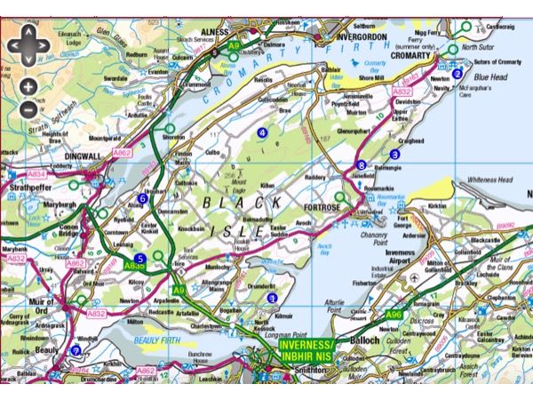
The walks are numbered and their locations are shown on the map:

- 1 Circular walk around Loch Lundie 2.8 miles
- 2 Circular walk from Cromarty to South Sutor and McFarquhar's Bed 4.4 miles
- 3 Linear walk from Eathie to Rosemarkie along the coast 7.3 miles
- 4 Circular walk in the Millbuie Forest 7.6 miles
- 5 A walk in the quieter parts of Monadh Mor bog forest 3.3 miles
- 6 A circuit of Drummondreach Oak Wood SSSI 1.5 miles
- 7 A walk beside the River Beauly and Beauly Firth 3.3 miles
- 8 A walk to Gallachy Hill 2.9 miles
- 9 The Jubilee Path to the Fyrish Monument 4.3 miles (beyond the Black Isle near Evanton)
There's a network of signposted Core Paths across the peninsula. Click below for detailed maps
- Culbokie & Millbuie
- Cullidudden and Jemimaville
- Cromarty, Eathie and Learnie
- Fortrose and Avoch
- Munlochy and Avoch
- North Kessock
- Muir of Ord and Monadh Mòr
- Conon Bridge and Maryburgh
The wonderful long distance walk The John o'Groats Trail crosses the Black Isle on Stage 1: Inverness to Culbokie and Stage 2: Culbokie to Alness.
If you're heading somewhere new to you, have a quick check before you go of the Scottish Outdoor Access Code . It says that you can exercise access rights for:
- Recreational purposes (such as pastimes, family and social activities, and more active pursuits like horse riding, cycling, wild camping and taking part in events)
- Educational purposes (concerned with furthering a person's understanding of the natural and cultural heritage)
- Some commercial purposes (where the activities are the same as those done by the general public), and
- For crossing over land or water.
The three key principles of the Code are:
- Respect the interests of other people
- Care for the environment
- Take responsibility for your own actions